Hold onto your Panama Hat … this is one exhilarating ride!
At 10,000 feet, the air is perceptively thinner in the Ecuadorean capital of Quito. Travelers puff and gasp the first few days of their visit. Stone steps and sidewalks seem steeper; footsteps tread more slowly. This ancient, beautiful city is home to over 2 million residents. It fills the valley at the foot of 15,710 foot high Rucu Pichincha with thousands of single-story simple homes, creeping halfway up its green slopes. In the city center is the international airport, laid out on a dried-up lakebed. Still, my lungs longed for the warm sea-level coast, with its cool Pacific breezes.
While most travelers hop the 40-minute commuter jet from Quito to the coastal city of Manta, We chose the 7-hour overland route through the Andes mountains, in a taxi.
It was the rainy season in Quito. This city’s temperatures vary only a dozen or so degrees year round, maintaining a feeling of perpetual springtime. The journey began with navigating the drizzly, twisting streets filled with Sunday morning churchgoers.
As the crowded city dissolved into open road, mountains peeked through the open edge of the steep man-made ravine. Distant mountains, grayed out with aerial perspective, wore a froth of pale, translucent clouds. We continued to climb. The higher we traveled, the more a misty fog condensed into rain clouds crawling through the foliage. We began to see waterfalls cascading the sheer rock face of the mountains. Mile after mile of uninhabited cloud forest unfolded.
What lay ahead was the spectacular panorama of trees and vegetation clutching the sides of sheer, vertical cliffs. The road became a single lane in both directions, occasionally widening to allow for passing of slower traffic. As the road ascended the peaks, the air became ever thinner, wetter, colder.
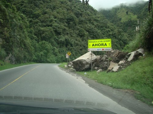
Everywhere “Ahora” signs warned of landslides. Rocks of all sizes were strewn across the road. Roads narrowed and entire lanes suddenly disappeared as the edges crumbled over the precipice. Few guardrails are seen. A yellow line marked 2-way traffic lanes, but it did little to deter drivers from passing in “No Passing Zones,” around blind curves, where the misty visibility shrouded traffic in either direction. Cars passed buses, passed trucks, passed cars in a kind of vertical challenge hopscotch. Switchback turns concealed any vehicles except those visible only a few yards ahead.
Every so often, I glanced at the speedometer. The driver was doing between 80 and 100 kilometres per hour. Yet, other cars, intra-city buses, and trucks sped by our little car.
All along the route, groups of men in hard hats and day-glo vests were building the road one shovel-full at a time. Others manned the bright orange dump trucks, and backhoes that were clawing a new road out of the massive granite mountainsides.
Here and there, the road surface had eroded to a consistency of corrugated cobblestone. The driver arm-wrestled the steering wheel as we slalomed our way across the bumps and potholes. There were few road markings, or signs. Guardrails, where they occurred, abruptly ended leaving unprotected sheer fall-offs and rock slides. Every few miles, a solitary homemade cross marked a spot where fellow travelers never completed their intended journey.
After a few hours of digging my nails into the taxi’s armrest, we reached the summit of the ridge, and began our decent. With each turn, as the Sierra Andes receded into the rearview mirror, the air became warmer, denser. We found it easier to breathe. Soon we were seeing small hamlets. Banana trees and palms replaced the deciduous trees of the higher altitude landscape. As we passed through the farmland, we saw cacao beans spread on the side of the road, drying in the sun. The carcass of a freshly slaughtered pig hung from a pole that was propping up the front corner of the tin roof of a wooden mountain shack.
A tropical landscape began to emerge. Solitary, doorless, thatched-roof huts, perched on stilts, appeared. Each having open-air eaves and a single window covered by a shutter, they began to dot the countryside. A Vietnamese mountain family would have felt perfectly at home in such a hut.

On and on we drove through the countryside, finding strange and wonderful sights. Rounding a sharp hairpin turn, we found a carving of the menacing face of El Diablo chiseled into a 20-foot high slab of rock face. The brave, anonymous sculptor had worked miles from any town.
Slowing to enter another small town, we found our path blocked by a gathering of townspeople attending the open-air funeral of some prominent local. They spilled out into the street, entirely filling the traffic lane, forcing us to drive into oncoming traffic to continue our journey. Hours later, we watched a truckbed full of joyful young men celebrating their soccer victory. They hoisted a small trophy, chanting their victory song. A large joy in a small town.
Near dusk, as we watched clusters of riders on burros and horseback gathering at a local hacienda to spend a Sunday evening together. We approached Montecristi, the town where the real Panama Hats and other crafts are fashioned. There, street vendors approached the car to sell fruit (the ubiquitous banana) and cookies.
At long last, we arrived in Manta and caught a glimpse of a cruise ship pulling out from its berth as it began to continue the journey southward down the coast. It was just after 6:30 pm. The sun had set over the Pacific horizon and it was nightfall.
A most exhilarating road trip. Sights, sounds and smells never to be experienced from an airplane’s altitude of 30,000 feet.
