By Saul Schwartz
For part of our first trip outside of the Washington, D.C. metropolitan area since the COVID pandemic, my wife Fern and I choose to drive about 575 miles to New Hampshire. The White Mountains highlight what is amazing and liberating about nature. Fern and I had never journeyed to the Granite State together before and we were excited to travel once again.
Staying in North Conway
We were pleased with the location of our Airbnb chalet in a residential area within North Conway. Airbnb offered many lodging options for around $200 per night, including fees for enhanced cleaning. With the White Mountains to the north and west, North Conway was an ideal gateway lodging location for our trip.
The town of North Conway (population 2350) itself was fun to walk along. The small town with its Main Street has quaint stores (including a 5 and 10 cent) and coffee shops. One afternoon we sat outside of the Met Café and Coffee House which featured a large variety of drinks (coffee, cappuccino, latte, expresso, cold brew, hot chocolate, tea) and several food options (bagels, muffins, pastries, desserts). We spent a little time at Settler’s Green, an outlet mall featuring over 70 stores, about one mile away from the town center.
North Conway was a good starting point for each day, regardless of whether we were traveling west on the Kancamagus Highway or north through the White Mountain National Forest on Route 302. As the commercial center of the White Mountains, we were fortunate to find all types of vegan food and desserts at the large grocery store, Hannaford Supermarket, on Route 16. This store stocked excellent locally made vegan desserts from Peace of Mind Baking Company, with exceptionally tasty brownies and cookies.
Covered Bridges
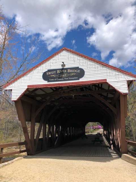
One of the attractions of the White Mountains is the large number of covered bridges. These covered bridges generally consist of a roadway supported on each side by a wooden truss and a roof. Local brochures identified 29 covered bridges in the White Mountains. We wanted to experience some of the covered bridge mystique and we saw three bridges.
We had a quiet picnic lunch in the parking area by the Swift River covered bridge, located in Conway at West Side Road, off Route 16. Originally built in 1869, a sign by this landmark covered bridge indicated that it had been restored in 1991 “though generous donations of many private citizens and the taxpayers of the town of Conway united to preserve a symbol of our community heritage.” The sides of the bridge are red, but the front is white. Picnic tables are placed inside the bridge, which is no longer open to vehicular traffic. The original covered bridge over the Swift River was destroyed by heavy rainstorms, but lumber salvaged from the bridge was used in its restoration.
Just a bit down West Side Road, the Saco River covered bridge is a little different than the Swift River covered bridge. Originally built in 1890, this one-way bridge is still open to traffic! The Saco River covered bridge can been seen from the Swift River bridge. This bridge was rebuilt after storm destruction, with a white front and red sides. There is a small parking area by the bridge.
We drove by the Bartlett covered bridge during our drive along Route 302, west of Glen. This red covered bridge now houses the Covered Bridges Gift Shop. Constructed in 1857, this bridge also spans the Saco River, but near Bartlett Village. The bridge was closed to vehicles in 1939 but was later rebuilt and renovated to house this antique and gift shop, which also sells home décor.
Tumbling Waterfalls
There are more than 100 waterfalls in the White Mountains. Many are easily accessible at roadsides or through short hikes. Their natural beauty provided an arresting display of nature’s power during spring runoffs. Twenty six of the falls have been identified as particularly attractive local sites to see in White Mountains brochures.
Diana’s Bath Waterfalls
Near North Conway, we took a short primarily flat hike (about .6 miles each way) to these beautiful falls. These falls are located off West Side Road, not far from Cathedral Ledge State Park. The total drop of the waterfalls is 75 feet. Diana’s Baths are a popular attraction and the parking lot is very large. A “rustic” bathroom is located at the trailhead. A $5 per vehicle fee is collected by the Forest Service at a self-service pay station (although the National Park Service Lifetime Senior pass is accepted for free entry).
These waterfalls consist of a series of pools, small waterfalls and cascades that stream from Lucy Brook. The trail to Diana’s Baths is called the Moat Mountain trail. The falls are named after the Roman goddess Diana. Signs explained that the baths were once privately owned. We enjoyed sitting and watching the falls from several different vantage points on top of huge boulders. On Mother’s Day, this site was so crowded that the parking lot soon filled up.
Kancamagus Highway (from Conway to Lincoln) (Route 112)
Established in 1959, the Kancamagus Highway stretches across the White Mountains for over 34 miles from Conway west to Lincoln, New Hampshire. Dedicated as the Northeast’s first national scenic byway, the highway offers outstanding opportunities for mountain and Swift River views. The road is open year-round and is named for a legendary Native American tribal leader (translated as the fearless one). Much of the highway was completed by the Civilian Conservation Crops and then finished by the state highway department. This mountain road winds through breathtaking vistas of the peaks, gorges, falls and the river.
Vehicles parked within the White Mountains National Forest are required to display a recreational pass. The pass costs $5 per day or $30 per year. However, the National Park Service Lifetime Senior pass is again accepted for free entry. Off of this road, you can hike to 5 different waterfalls. Locals refer to the road as “the Kanc.”
Rocky Gorge Waterfall and Lower Falls
These falls are both located near each other off the Kancamagus Highway in Albany. Both falls are close to the roadside and are very easily accessible through paved paths. Rocky Gorge is more impressive with its a ten-foot drop and rapids travel through the narrow gorge. Waster constantly rushes through the powerful narrow gorge. Best views were from directly above the gorge on the footbridges. At the Lower Falls, the Swift River drops many feet over smooth granite rocks into a large pool.
The Swift River has worn a narrow cleft in solid rock in the are known today as Rocky Gorge. Signage indicated that the gorge was carved by glaciers. We were told that the Lower Falls is the most popular stop along the Kanc. Large parking lots are located by both falls, along with “basic” restroom facilities.
Sabbaday Falls
These falls are located near the middle of the Kancamagus Highway. They are accessible after a moderately easy .3 mile high, with some modest hill, on the Sabbaday Brook trail. The 45-foot waterfall and gorge are particularly breathtaking. The falls feature a series of picturesque cascades in a narrow flume, with sparkling pools below. Bridges and observation decks provide the best views.
The gorge was carved by large volumes of water from melting glaciers. There are three parts to these attractive falls, with a lower circular pool. “Basic” restrooms and a picnic area were located by the parking lot.
Heading North along Route 302
At many points, this route is just as scenic as the Kancamagus Highway. We passed many world renown ski resorts as we headed north from Conway towards Mount Washington. Saco River views are seen along much of this road.
Silver and Flume Cascades
North along Route 302, both falls are easily accessible at the roadside. Parking lots are available across the road from both falls. These amazing falls are located near Crawford Notch State Park. Both falls are very narrow and vertical. These falls drop about 300 feet along a series of cascades and plunges, flowing down to the Saco River. They are within walking distance from each other. Here we simply stopped for the views, as there were no trails at this location.
Crawford Notch State Park (near Hart’s Location)
This beautiful park contains the Silver and Flume waterfalls, along with spectacular mountain views. We stopped as we entered the park at a very scenic overlook which provided us with our first sighting of the snow-capped Mount Washington. No fee is required to drive into the park on Route 302.
We had a picnic lunch outside Willey House, where many picnic tables overlook the Saco River. This was a very peaceful and quiet area. After lunch, we went for a short hike along the nearby Appalachian Trail (which sits on both sides of Route 302). Signage indicated that this portion of the trail was 12.5 miles away from Mount Washington and 332.4 miles away from where the trail ended in Maine. The Willey House is the site of a landslide in 1826 in which seven members of the Wiley family and two workers perished. The Willey House gift shop and information center were not open yet for the season. The location of the Willey House is identified by a stone monument on the grounds.
Mount Washington Cog Railway
The trip to the top of Mount Washington in the Presidential Range of the White Mountains took about 45 minutes each way from the base. The base camp is about six miles from Bretton Woods. At the Marshfield base station, a small interactive museum provides videos and informational stations about changes in the railway over the years. Also, there is a small food court and a gift shop in the base station building. At the base station, the elevation is 2700 feet above sea level. On this day we experienced light snow and rain at the base.
The railway completed its first trip to the summit in 1869. It is the world’s oldest mountain-climbing cog railway. Now, more than a century and a half later, the Cog Railway dramatically ascends to the summit of the highest peak in the northeastern United States (6288 feet). Today’s power consists of a fleet of biodiesel locomotives. The on-board conductor provided an entertaining narrative related to sites along the way (e.g., when the Appalachian Trail crossed the track, the half-way house with its elevation of 4500 feet noted).
In May, the weather observatory, cafeteria, gift shops and observation deck, museum and exhibits at the top of Mount Washington were not open. During our visit, the views were disappointing because visibility was low. On this day, we experienced a taste of the world’s worst weather. The weather at the summit rivaled that of Antarctica. Conditions above the tree line were quite different from those at the base station. We traveled through three climate zones to reach a winter snowscape with extreme winds of over 40 miles per hour. Because the conditions were so severe and the facilities on the summit were closed, we took the next train back down after spending just a few minutes at the peak.
Tips
Wildlife: Everyone wants to see a majestic moose. Despite the numerous “Moose Crossing” and “Bear Crossing” signs, the only moose and bear that we saw in May were statutes in various North Conway locations. We were told that May is not a great time for either a moose or bear sighting.
Bike rides and walks: Although we took our bikes on this trip, most of the trails in the White Mountains are made for mountain bikes. Fern and I did enjoy one bike ride in North Conway through the residential community where we stayed. The roads were well-paved and we found a route that was not as typically hilly as the surrounding area! We also enjoyed walking through the town of North Conway and its residential neighborhoods.
Congestion on the roads: Our GPS indicated that this trip would take 9 and one-half hours. Due to surprisingly heavy traffic volume, stops for food or rest breaks, and construction (primarily in New Hampshire), the trip took almost 13 hours.
The cog railway: Tickets were expensive ($74.50 per adult). Had we known in advance that the visibility on the summit was so poor and that the facilities were closed, we probably would not have taken this trip. Neither the railway’s web site nor the on-site staff told us about either.
May is still the off season: Several attractions were not yet open for the season. We would had seen the Flume Gorge in Franconia State Park had it been open. Nevertheless, there were plenty of attractions to enjoy in May, with smaller crowds at the sites.
Restrooms are basic and rustic: Although there were facilities at each site, the restrooms within the National Forest were not very well maintained and rather unclean.
The locals were very friendly: Fern and I really enjoyed our mountain getaway. Our encounters with Granite Staters were very positive. As we walked through North Conway, locals greeted us not as tourists, but as New Hampshirites.
